Length — 315km (first walked 2018)
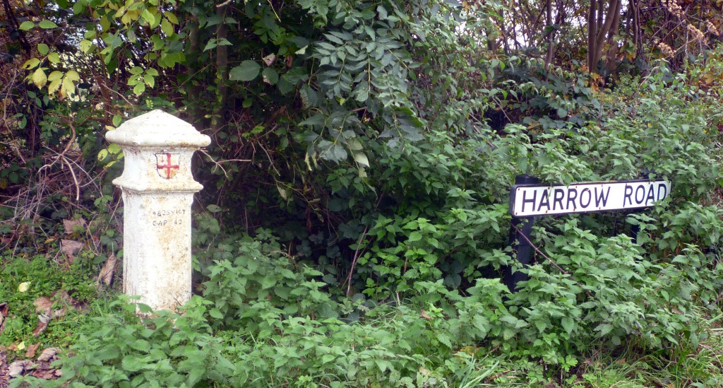
Travel through the outer areas of London, and you are likely to come across little white cast-iron posts with the City of London shield. These were erected in the 1860s, along with other markers in stone, to delineate the boundary, within which any inbound shipment of coal was liable to a tax. Of the posts which remain, some are situated beside railways and canals (and the Thames), and others are out in open land, but the majority stand today beside roads.
This route joins up these into a circuit of London. Staines-upon-Thames and the mouth of the River Darent are the riverside extremes; in the north, the route passes through Theydon Bois, Potters Bar, Watford and Uxbridge, while the southern section takes in Epsom Downs, Biggin Hill and Swanley. A ferry is taken across the River Thames at Shepperton.
You are encouraged to read the introduction first, as it sets the scene, describes general logistics, and outlines the conventions used in the sectional documents.
The route is described, with full details of public transport and facilities such as shops and pubs, in a single document, with sections mapped as below. The URL for each map is quoted at the appropriate point in the narrative.
| Purfleet station to Eastbrookend Country Park Visitor Centre 14.4km; 26m ascent; 2hr 55min | Map |
| Eastbrookend Country Park Visitor Centre to Chigwell Row 14.5km; 108m ascent; 3hr 04min | Map |
| Chigwell Row to Theydon Bois 10.3km; 118m ascent; 2hr 15min | Map |
| Theydon Bois to Bumble’s Green 14.3km; 197m ascent; 3hr 11min | Map |
| Bumble’s Green to Wormley 8.8km; 71m ascent; 1hr 52min | Map |
| Wormley to Potters Bar 17.21kmk; 276m ascent; 3hr 54min | Map |
| Potters Bar to London Colney 14.8km; 109m ascent; 3hr 05min | Map |
| London Colney to Watford (Link Road) 19.26km; 153m ascent; 4hr 04min | Map |
| Watford (Link Road) to Batchworth Heath 15.2km; 229m ascent; 3hr 25min | Map |
| Batchwortth Heath to South Harefield 14.6km; 68m ascent; 3hr 02min | Map |
| South Harefield to Thorney 13.9km; 17m ascent; 2hr 48min | Map |
| Thorney to Staines-upon-Thames 15.6km; 31m ascent; 3hr 10min | Map |
| Staines-upon-Thames to Shepperton Ferry 9.0km; 0m ascent; 1hr 48min | Map |
| Shepperton Ferry to Esher station 16.0km; 32m ascent; 3hr 15min | Map |
| Esher station to Malden Rushett 11.3km; 98m ascent; 2hr 25min | Map |
| Malden Rushett to Tattenham Corner 13.6km; 196m ascent; 3hr 02min | Map |
| Tattenham Corner to Chipstead 17.4km; 231m ascent; 3hr 52min | Map |
| Chipstead to Warlingham 17.1km; 398m ascent; 4hr 05min | Map |
| Warlingham to Leaves Green 9.8km; 138m ascent; 2hr 11min | Map |
| Leaves Green to Chelsfield station 14.9km; 205m ascent; 3hr 18min | Map |
| Chelsfield station to Swanley 12.7km; 127m ascent; 2hr 45min | Map |
| Swanley to Erith station 21.0km; 145m ascent; 4hr 26min | Map |
Disclaimer and permissions
Disclaimer and advisory notices
Note that lwalks.london can accept no responsibility for content on an external site or in an external publication, nor for any action by an external site which renders our content or link outdated or unworkable. Furthermore, lwalks.london retains the liberty to unlink external content at any time if the content loses relevance to the linking page(s).
Images used on the lwalks.london site are either owned by lwalks.london, or are subject to a licence-to-use held by lwalks.london. These images must not be further used by any third party without the explicit permission of lwalks.london, or of the original image licensor. A small number of images are in the public domain.
Routes are to be followed entirely at the walker’s own risk: lwalks.london can take no responsibility for any inconvenience, damage, loss or injury caused by attempting to follow a route, which is no more than a mere suggestion of a possible enterprise.
We should be happy to learn of any changes to the line of a walk and/or its attendant facilities, or to consider an image which you own for inclusion on the site, lwalks.london thus being granted a free and non-exclusive licence to use the image anywhere on its site. Please contact us.
