Length — 321km (first walked 2016-17)
I was looking around for a route which would link up all the boroughs in one walk, and decided to connect the highest points in each of our thirty-two London boroughs (plus that of the City of London, of course). Initial planning gave me a total length of 300km, but plans never survive contact with the enemy! Once I had the route under my feet, and had seen the options on the ground, it became 320km. The rough shape of the route gives it its less formal name — the Capital C. Note the “Kingsbury fjord” in the north-west to collect the Brent summit!
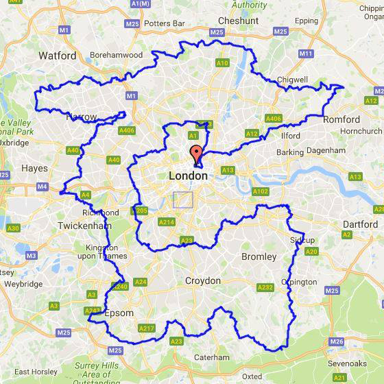
Naturally, the route is coincident with several established routes (such as the London Loop and the Capital Ring) in places: there are only so many options to get through a particular area. But the constraints of visiting the summits (some of which are far from lofty) made me focus on the places between, and there are lots of fascinating histories to be found on the streets. Some of the transitional corridors of urban streets are just that, but many have real reasons to choose to go there, whether that may be the general architecture of the place, a surprise building or vista, or a rich history of an area or a building. Like the Loop, the London Summits Walk will occasionally stray beyond the strict London boundary, most notably in the south-west corner.
The walk is clearly a circuit, and may therefor be started or finished at any point, but there is a ‘conventional’ start and finish point at Chancery Lane station, near the summit of the County and City of the City of London, and that is reflected in the numeration of the route-notes.
The route is described in a single descriptive document (of just over 300 pages), and the maps are referenced at the start of each section. There are four major areas of the walk, laid out and linked in the table below. Each of these links will show you the sections of the route, of which there are 23 in all.
| Inner arc Angel, Finsbury Park, Hampstead Heath, Swiss Cottage, Kensal Green, Putney, Wimbledon, Crystal Palace, Shooter’s Hill, Sidcup | 82.6km 868m ascent |
| South-east and south Sidcup, Petts Wood, Westerham Heights, Farthing Down, Ashtead Common, Malden Rushett | 64.6km 1152m ascent |
| West Malden Rushett, Kingston, Richmond Park, Horsenden Hill, Kingsbury, Ruislip Lido, Stanmore Common, Stanmore | 87.7km 888m ascent |
| North and north-east Stanmore, Moat Mount Park, Trent Park, Enfield Lock, Havering-atte-Bower, Wanstead Park, Victoria Park, Smithfield, Chancery Lane | 85.9km 919m ascent |
Disclaimer and advisory notices
Note that lwalks.london can accept no responsibility for content on an external site or in an external publication, nor for any action by an external site which renders our content or link outdated or unworkable. Furthermore, lwalks.london retains the liberty to unlink external content at any time if the content loses relevance to the linking page(s).
Images used on the lwalks.london site are either owned by lwalks.london, or are subject to a licence-to-use held by lwalks.london. These images must not be further used by any third party without the explicit permission of lwalks.london, or of the original image licensor. A small number of images are in the public domain.
Routes are to be followed entirely at the walker’s own risk: lwalks.london can take no responsibility for any inconvenience, damage, loss or injury caused by attempting to follow a route, which is no more than a mere suggestion of a possible enterprise.
We should be happy to learn of any changes to the line of a walk and/or its attendant facilities, or to consider an image which you own for inclusion on the site, lwalks.london thus being granted a free and non-exclusive licence to use the image anywhere on its site. Please contact us.
