
The Dutch walkers’ organisation, Wandelnet, has started devising routes from central points of their towns and cities (usually the main railway station) out to points on the outskirts which link to the national network of footpaths. I decided to explore the same idea for London. Of course, London is much bigger than, say, Amersfoort, so these walks are longer than their Dutch equivalents. Like the Dutch routes, though, they are designed to be joined at intermediate points close to home.
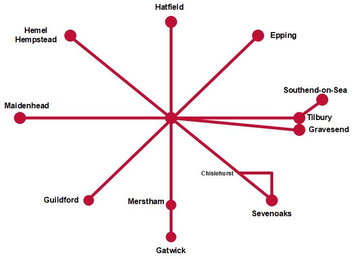
There is a radial route for each of the eight main points of the compass running out of London, but of course I ended up with nine routes: the eastward direction has one route on each side of the broadening Thames (sad to relate, but these two may no longer be linked using the ferry between Tilbury and Gravesend, which was discontinued in 2024). Each route starts at Nelson’s Column in Trafalgar Square.
The routes have now been worked out, written up, and placed on this site, but I always have my eye on one or two variations which may improve the experience. As the routes are walked and re-walked, the documentation will be uploaded and linked from the home page for the relevant route.
The destinations and skeleton routes are given below. Including both Sevenoaks alternatives, this brings the total distance to a touch less than 550km — the equivalent of walking from Trafalgar Square to the Scottish border at Marshall Meadows, north of Berwick-upon-Tweed … or, in the opposite direction, to Metz. The total ascent is a shade short of 5300m, just a few rocks less than four Ben Nevis climbs from Fort William.
You are encouraged to read the introduction to the routes first: it gives overall recommendations and explains the conventions in the main texts.
The maps (linked from the individual walk pages) will show on a plain map; subscribers to OSMaps Online (a no-brainer investment for any walker) will be able to see the route on proper OS maps at 1:50000 and 1:25000 scales.
East (north of the Thames) — Southend-on-Sea (96.3km; 325m ascent)
Via Tower of London, Limehouse Cut, Three Mills, Beckton, Dagenham, Elm Park, South Ockendon, Chadwell St Mary, Tilbury, Coalhouse Fort, Corringham, Pitsea, Benfleet and Leigh-on-Sea.
North-east — Epping (35.6km; 292m ascent)
Via Aldwych, Smithfield, Hoxton, Stratford, Wanstead Flats, Snaresbrook and Chingford.
North — Hatfield (49.2km; 422m ascent)
Via Angel, Clissold Park, Finsbury Park, Highgate, Mill Hill, Barnet and South Mimms.
North-west — Hemel Hempstead (53.1km; 544m ascent)
Via Primrose Hill, Hampstead Heath, Welsh Harp, Barn Hill, Harrow Hill, Pinner, Oxhey Woods, Cassiobury Park and Kings Langley.
West — Maidenhead (60.6km; 242m ascent)
Via Hyde Park, Holland Park, Ravenscourt Park, Gunnersbury Park, Boston Manor, West Drayton, Iver, Langley Park, Stoke Poges, Burnham Beeches and Cookham.
South-west — Guildford (60.7km; 418m ascent)
Via St James’s Park, Battersea Park, Clapham Common, Wimbledon Common, New Malden, Hogsmill Valley, Ashtead Common, Leatherhead, Effingham Junction, Clandon and the Wey Navigation.
South — Gatwick (60.4km; 791m ascent)
Via Parliament Square, Kennington Park, Brockwell Park, Dulwich, Penge, South Norwood, Lloyd Park, Sanderstead, Coulsdon Common, Merstham, South Nutfield, Outwood and Smallfield.
South-east — Sevenoaks (51.0km with 662m ascent
Via Elephant and Castle, Burgess Park, Peckham Rye, Honor Oak Park, Beckenham Place Park, Chislehurst, Petts Wood, Farnborough, Knockholt Pound, Dunton Green and Riverhead.
Darent Valley alternative conclusion (25.8km; 326m ascent)
From Chislehurst via Swanley, Lullingstone, Otford, Dunton Green and Riverhead.
East (south of the Thames) — Gravesend (51.1km; 468m ascent)
Via Hungerford Bridge, Bermondsey, Southwark Park, Deptford, Greenwich Observatory, Oxleas Wood, Welling, Old Bexley, Joyden’s Wood, Sutton-at-Hone, Southfleet and Rosherville.
I have now started developing a route to link all of these endpoints in a huge loop around the Home Counties. This is a work in progress, called the Circumcardinal Walk.
Disclaimer and advisory notices
Note that lwalks.london can accept no responsibility for content on an external site or in an external publication, nor for any action by an external site which renders our content or link outdated or unworkable. Furthermore, lwalks.london retains the liberty to unlink external content at any time if the content loses relevance to the linking page(s).
Images used on the lwalks.london site are either owned by lwalks.london, or are subject to a licence-to-use held by lwalks.london. These images must not be further used by any third party without the explicit permission of lwalks.london, or of the original image licensor. A small number of images are in the public domain.
Routes are to be followed entirely at the walker’s own risk: lwalks.london can take no responsibility for any inconvenience, damage, loss or injury caused by attempting to follow a route, which is no more than a mere suggestion of a possible enterprise.
We should be happy to learn of any changes to the line of a walk and/or its attendant facilities, or to consider an image which you own for inclusion on the site, lwalks.london thus being granted a free and non-exclusive licence to use the image anywhere on its site. Please contact us.
