The perfect guide-book

George Orwell tried to describe his perfect pub, which he called The Moon under Water — drawing together the best parts of other pubs: his perfect pub never existed. Nor are any of the pubs with that name anywhere near perfect. Not from that company.

Bill Bryson, in The Lost Continent, sought out the quintessential small American town in the same way, creating the town of Amalgam — again, it does not exist.

I have always harboured a distrust (as deep as the Marianas Trench) of the “one favourite” trope, which appears everywhere from Desert Island Discs to the trite sixty-second space-waster “interviews” to be found in every news outlet. How could anyone live such a one-dimensional life?

So what makes the perfect guide-book for walkers? Does it exist — can it exist? I was chewing the internet fat with Mark Richards the other day, and we got onto the topic. Was that just two aged walkers looking back to what was considered palatable when we were 35? There are more than enough people who stop developing their reading (and other) preferences then: this may be advantageous for publishers who can therefore reprint outdated books and formats, but is that useful? It calls to mind a friend’s attempt to navigate across Coventry in the 1980s with a map showing the “proposed route of new M1 motorway” off to the east. We can identify failings in individual guides, but nobody surmounts all the difficulties at the same time. There is no perfect guide-book.

Terse or verbose?
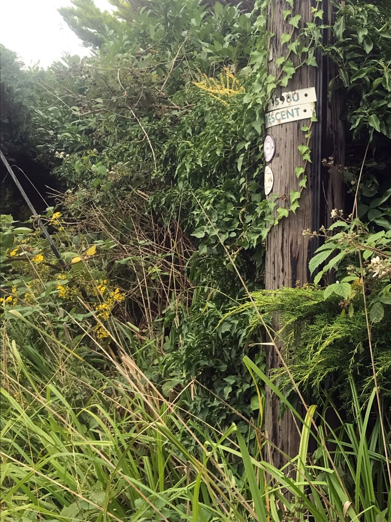
Some directions are terse almost to the point of telegraphese. L on rd; L at pub; L at PO. That seems like you’ll be back where you started, but the author has missed out all the right-hand bends in between. Then there are the guides which take half a page to cross a couple of fields, pointing out the direction with reference to the lichen on a utility pole. The better guide hits the spot where all the info is necessary and sufficient. And the abbreviations should be intuitive for those whose first language is not that of the area being walked (hint, use icons for changes of direction and such like).

Logistics
Some guide-books give you the history of public transport every time a bus stop or station is reached. Others hide bare details (often just URLs) in an appendix. For a day’s walk, brief excerpts (again, necessary and sufficient) within the narrative — bus at xx36 to Kirkloaning (not Sunday) — with a backup generic URL (such as traveline) in the preamble to cope with timetable changes. For a multi-day walk, a transport/accommodation section with a bus or hotel icon in the text makes reading the route-notes easier. No prices, of course, just £, ££, etc. (or , €€, etc., and so on) with a table which gives the median price within each category with a reference date in the preamble, so that readers may adjust for inflation.

Maps
Spidery and inaccurate hand-drawn maps should be left in the past. If you cannot draw accurate maps with good visibility (through spectacles in the mist, for example), use the services of a good cartographer (the Ordnance Survey, for example) and/or back them up with a downloadable GPX file. And leave at least five minutes’ overlap between consecutive maps: when you see “Stone” at the end of one map and “henge” at the start of the next, you know that the author is just a miser. Two-way guides are notorious for having “second choice” directions adjacent to the wrong map — buyer beware, but author take care!

Extra information
All the pages about geology, social history and the like pad out the book with extra weight: they could be replaced by simple URLs to the same information on the author’s (or publisher’s) website. Even worse when the information is in boxes scattered around the book, taking up much more space than the route-notes. These extras are really for researching at home, so separate them out so that they may be enjoyed there, and cut to the chase on the text the walker really needs on the ground.

Updates
There is no excuse for working with out-of-date instructions. A URL to a table of updates since the last edition is enough. All you’ll need on the walk is a slim volume of notes and maps, and a few pages of printout updates which you have cross-referenced by annotations in the book. You’ll be buying the next edition when it comes out if you walk the route again, so don’t fret about spoiling the pristine page.

Summing up

The above paragraphs are my own preferences, which may be summed up as “minimise weight on the route, and use available technology”. I like looking at Wainwright’s drawings, but they are historical, just like the strip-maps of the Great North Road from the days of the stagecoach. My copy of A Coast to Coast Walk is still bum-concave forty years after I last walked the route with the book in my back pocket, but even in the late 1970s, there were outdated details. I would never use it today, preferring up-to-date options, though it is still nice to leaf through from time to time. Oh, and any format bigger than that book is too big for a normal pocket (jacket or trouser).

Much of the information other than the route-notes is either static (give or take the discovery of a new Roman villa or a new theory of boundary marks) or it is liable to render data out of date soon after publication. This is where our friend the internet makes it much easier than in the Wainwrightocene era: we must make best use of it.

Some authors split the publication into two separate books, often with maps in one and text in the other. We could usefully have map, route-notes (but not the padding narrative) and links to logistics together, with all the research-at-home extras in the other volume (if it is decided that downloading is too modern).

But these are just my preferences: others will have different pet inclusions.

Say it again, and keep saying it — there is no perfect guide-book.

.

Lea Valley Walk — Day 1

Now that the first sector of my proposed walk around the termini of my London radial walks (from Southend to Epping) is complete, the most recent day having done double duty with the final instalment of the Essex Way, I was looking round for another walk. Since the circumcardinal route‘s next sector follows the Lea Valley Walk from Cheshunt to Hatfield, it seemed a good idea to fill in the section from the Thames to Cheshunt.

I arrived at Canning Town Tube station at 0745 on a bright September morning, and set off for Trinity Buoy Wharf, where the River Lea empties into the Thames. The area they call City Island (it is not: it is merely part of a peninsula) is a soulless bundle of antiseptic flats, the architectural equivalent of a bottle of hand-sanitiser, and this reformulation will seep under the elevated roadway to colonise Trinity Buoy Wharf and erase as much history as it can get away with.

Trinity Buoy Wharf: the ghost of history

The mouth of the river is opposite the Dome, which looks curiously flat from across the river: there is the lighthouse and an old lightship amongst the recent encrustations. So, back under the road and turn left, only to find the way gated and locked. Another alleged access was boarded off, so there was no alternative but to traverse the dystopian City Island and return to Canning Town. Down to the Tube, through the station, up to the bus station, cross the A13, and make for Star Lane DLR station along the dilapidation and litter of Stephenson Street. Turn left, and left again at the coffee roasters, across the bridge at Cody Wharf, and at last I was walking along the river.

The lower Lea and “City Island”, framed by the utility arch at Cody Dock

And that was the story of the next three hours. I picked up the Lee Navigation at Bow Locks, and left for the day at Ponders End — appropriately, because the slowly evolving linear landscape was good for pondering. Except, of course, at such pinch-points as the approach to the North Circular, where the path narrows to be just about wide enough for two non-obese walkers to pass, and nowhere near safe enough for a walker/cyclist meeting.

Looking downstream from Twelvetrees Bridge, with Bow Locks and the Limehouse Cut on the right

By Ponders End, there was a gratifying increase in the semi-rural, which bodes well for the next section. However, it must be noted that the hard surface (whether tarmac, paving slabs, or just the compaction of the towpath down the centuries) begins to jar on the legs: I used calculations of probable stages ahead to justify leaving for lunch when I did.

Traversing Essex

During August 2021 (well, with a few days’ overhang into July and September), I walked in Essex. I had already decided that my first post-Covid extended walk outside London would be the Essex Way, but I also wanted to begin a walk encircling the capital to link up the termini of my London radial routes using named footpaths (of which the first two were the Saffron Trail and St Peter’s Way). I used public transport to and from the routes from my home on the western edge of London (LB Hillingdon), and carried a set of maps for the next stage of each route, just in case I missed a train at Liverpool Street. My two routes converged on Ongar, and the morning from there to Epping on the Essex Way did double duty.

The Essex Way was generally well waymarked and in good walking condition: my staging-points were Harwich, Wrabness, Manningtree, Great Horkesley, White Notley, Great Waltham and Chipping Ongar, then on to Epping

Saffron Trail: the Crouch estuary west of Hullbridge

The other route had staging posts at Southend, Hockley, East Hanningfield (where I switched from the Saffron Trail to St Peter’s Way), Margaretting and Chipping Ongar, then walking on to Epping.

OK, let’s cut to the chase. The Saffron Trail’s waymarking is often missing, and what is there is often perverse. This combines with a fetish for avoiding paths used by other named routes, such as the Roach Valley Way, I remember this sort of route, devised by on-spectrum “must save every footpath” RA members, from my days administering the National Register of Long Distance Paths, back in the day when it was independent of special-interest lobbies. The result is that there are stretches which pass through the thickest of thickets, and I have the flesh wounds to prove it: a soupçon of worldly-wise pragmatism could have avoided all this. It’s not as if the combined footfall of the Saffron Trail and the Roach Valley Way would have pounded the footpath into oblivion, even if the perpetrators of either had believed their own hype.

Poor waymarking on the Saffron Trail north of Battlesbridge

The route of St Peter’s Way is perhaps a little better, though one often has to walk beyond a waymark and see what is intended in the opposite direction before stepping forward: in both of these routes, the waymarking has been done by people who have no need for the waymarking to decide on the route: there is a serious lack of a competent Devil’s Advocate for each of the two routes.

A note on the Essex Way section from Great Waltham to Chipping Ongar. I broke at Willingale, the half-way point, but the bus went off-piste unannounced, and I was forced into the extra 8km. As I was passing the library in Chipping Ongar, the hourly bus to Epping passed, and it was almost 14 hours after setting off that I arrived home. The lack of information was a serious blot on the reputation of First Essex.

Overall, the double traverse was good, but there needs to be continued interest in St Peter’s Way and (particularly) the Saffron Trail. The latter has the air of a route devised by an individual who lost interest, and whose successors in the little group have had no interest in keeping it going. If that is the case, the route should be struck from the maps as an outdated ego-trip.

Crusader’s Tomb, Greensted church

Completing the Ring around the Underground

Having set out from Upminster in January 2020, and having had a year’s break because of Covid, I have at last reached Upminster again.

Beam Valley Park

The final section, from Epping to Upminster, took three days to beat out: the first day ended at Stapleford Abbotts accompanied by stings, scratches, skin punctures, and rank agricultural waste from the knees south. Everyone was suddenly keen on social distancing on the Tube home that day! Back to the map, then back to Epping, with a new route via Abridge. Still challenging, but I arrived at Noak Hill with all limbs attached, and took a reviving pint before the bus/train/tube/bus trip home (almost three hours, and all within London). The last part from Noak Hill, which I had smugly pigeon-holed as “suburban”, had plenty to occupy me: in particular, a bridge was out and no directions for an alternative southbound route.

Uxbridge High Street

But that was just the final section: looking at all 22 sections, there was a diverse mix of suburbia and what would pass for wilderness in and around the capital. Throughout the urban stretches, there was always a park or a piece of woodland coming up. The rural sections in the north and north-east held diversity, from the Chess Valley (almost manicured in places) to the unshaven final section. The total came in just over 300km, with a little over 2700m of ascent (two Ben Nevis climbs and a couple of Hampstead Heaths thrown in). The sections which strayed into Hertfordshire and Essex need careful transport planning, as does any interaction with the 375 bus (one every 90 minutes six days a week) in Havering-atte-Bower.

Central Park, Harold Hill

The entire route is now written up — happy Tube-ringing!

Repurposed “tin tabernacle”, Chandler’s Cross, west of Watford

The Ring around the Underground is now NLE-ready

After a year’s hiatus, I have finally walked the route of the Ring around the Underground from Merton Park to Wimbledon, adding an extra 20km to the route as it tumbles down to Battersea Power Station station (at the time of writing, still a building-site mess) and back up to Wimbledon. There is a fair amount of suburbia in these two new sections, but also Clapham and Wandsworth Commons, the River Wandle, Battersea Park, and some tiny oases of green among the railway-spaghetti that is Clapham Junction.

River Wandle, looking upstream from Trewint Street, Earlsfield

In addition, I have now progressed around the Tube’s “top-left corner”: the route is now written up and linked from the route’s homepage as far as Mill Hill East.